


4.1 km | 5.5 km-effort
![Trail On foot Dolní Morava - [Č] Žibřidovice - Sušina - Photo](https://media.geolcdn.com/t/1900/400/3ab21def-abb9-4035-a5e9-3dd24c499c62.jpeg&format=pjpeg&maxdim=2)

Tous les sentiers balisés d’Europe GUIDE+


FREE GPS app for hiking
 SityTrail
IGN / Geographical institutes
SityTrail World
The world is yours!
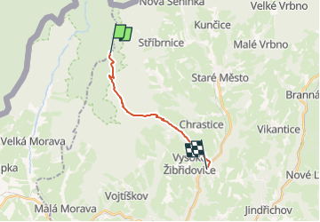
Trail On foot of 10.6 km to be discovered at Northeast, Pardubický kraj, Dolní Morava. This trail is proposed by SityTrail - itinéraires balisés pédestres.
Trail created by cz:KČT.
![Trail On foot Dolní Morava - [Č] Žibřidovice - Sušina - Photo 1](https://media.geolcdn.com/t/2048/auto/9eb3cea3-fff9-4d89-ae4b-51b7786c6ae1.jpeg&format=jpg&maxdim=0 "Trail On foot Dolní Morava - [Č] Žibřidovice - Sušina - Photo 1")
![Trail On foot Dolní Morava - [Č] Žibřidovice - Sušina - Photo 2](https://media.geolcdn.com/t/2048/auto/69b3f8a9-446a-4bef-a149-8d46410c433f.jpeg&format=jpg&maxdim=0 "Trail On foot Dolní Morava - [Č] Žibřidovice - Sušina - Photo 2")
![Trail On foot Dolní Morava - [Č] Žibřidovice - Sušina - Photo 3](https://media.geolcdn.com/t/2048/auto/05401107-eeef-4342-9e77-429f25b517fa.jpeg&format=jpg&maxdim=0 "Trail On foot Dolní Morava - [Č] Žibřidovice - Sušina - Photo 3")
![Trail On foot Dolní Morava - [Č] Žibřidovice - Sušina - Photo 4](https://media.geolcdn.com/t/2048/auto/acb891d8-93bb-4d74-9ee2-3459fa0811e9.jpeg&format=jpg&maxdim=0 "Trail On foot Dolní Morava - [Č] Žibřidovice - Sušina - Photo 4")
![Trail On foot Dolní Morava - [Č] Žibřidovice - Sušina - Photo 5](https://media.geolcdn.com/t/2048/auto/d4dd6688-304b-43a1-a038-2af7e33807d6.jpeg&format=jpg&maxdim=0 "Trail On foot Dolní Morava - [Č] Žibřidovice - Sušina - Photo 5")
![Trail On foot Dolní Morava - [Č] Žibřidovice - Sušina - Photo 6](https://media.geolcdn.com/t/2048/auto/4fcb52aa-88a6-4e6a-b414-fe8f12d73765.jpeg&format=jpg&maxdim=0 "Trail On foot Dolní Morava - [Č] Žibřidovice - Sušina - Photo 6")
![Trail On foot Dolní Morava - [Č] Žibřidovice - Sušina - Photo 7](https://media.geolcdn.com/t/2048/auto/1bc2e5a5-9472-43ff-9bcf-0b7134cc9dcb.jpeg&format=jpg&maxdim=0 "Trail On foot Dolní Morava - [Č] Žibřidovice - Sušina - Photo 7")
![Trail On foot Dolní Morava - [Č] Žibřidovice - Sušina - Photo 8](https://media.geolcdn.com/t/2048/auto/c7100e8c-936a-49d8-80fb-65c33da13dc4.jpeg&format=jpg&maxdim=0 "Trail On foot Dolní Morava - [Č] Žibřidovice - Sušina - Photo 8")
![Trail On foot Dolní Morava - [Č] Žibřidovice - Sušina - Photo 9](https://media.geolcdn.com/t/2048/auto/c21d4e80-4aa4-46ad-a405-d2957c9d0d06.jpeg&format=jpg&maxdim=0 "Trail On foot Dolní Morava - [Č] Žibřidovice - Sušina - Photo 9")
![Trail On foot Dolní Morava - [Č] Žibřidovice - Sušina - Photo 10](https://media.geolcdn.com/t/2048/auto/3ab21def-abb9-4035-a5e9-3dd24c499c62.jpeg&format=jpg&maxdim=0 "Trail On foot Dolní Morava - [Č] Žibřidovice - Sušina - Photo 10")
On foot